


Part 148: A New Year in the San Gabriels – From Angeles Crest Highway to Eternity
Published January 4, 2025. Updated January 6, 2025.

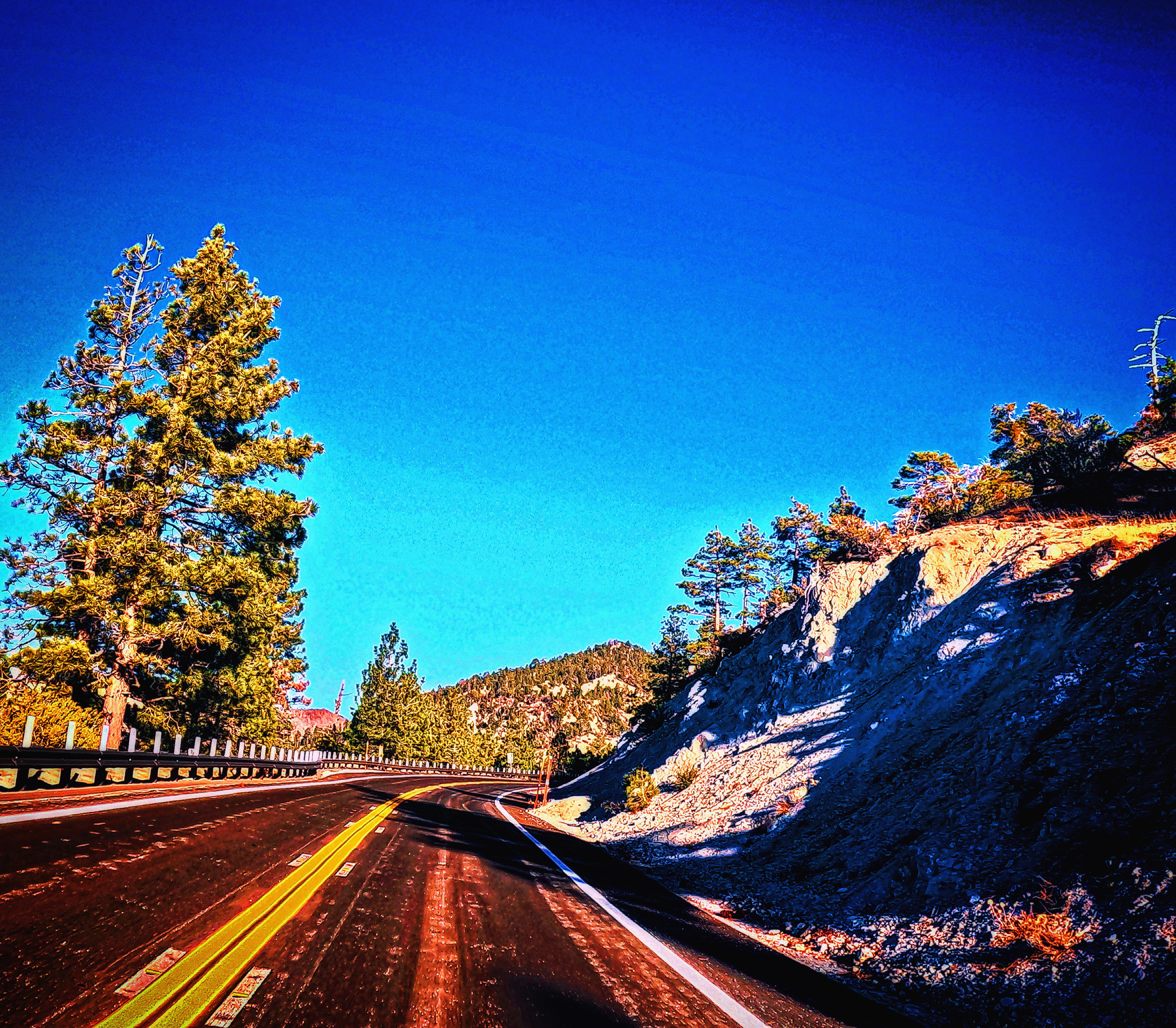
Photo of the Angeles Crest Highway (SR 2) turning in the so-called High Country where pine trees predominate the landscape by author (GoPro Hero 11 Black).
Please support my work with your subscription, or for direct support, use Venmo, CashApp, PayPal, or Zelle using zachary.b.ellison@gmail.com
By Zachary Ellison, Independent Journalist
The discarded black and gold New Year’s themed hat along the Mount Wilson Red Box Road was a clear reminder that a whole new calendar year was upon us. Whoever had tossed it or otherwise perhaps had it blown off their head hadn’t returned for their head cover. I had gunned it up the Angeles Crest Highway more than usual on the clear, sunny day, which lately has been unusual. The San Gabriel Mountains, the backdrop for Los Angeles, have yet to receive any significant amount of snowfall. Even amidst what’s now being widely regarded as an emerging drought, the marine inversion layer had resulted in a number of days of stifling air pollution over the Los Angeles Basin, with officials issuing warnings against burning wood. Two intrepid hikers had reached the benchmarked summit of the legendary mountain with its pioneering astronomy facilities coming up the newly reopened trails from Chantry Flats. They were determined to complete the loop back down to Sierra Madre, declining my friendly offer of granola bars.
Without any clear indicator that winter storms are inbound, the lack of snowfall in Southern California’s transverse mountain ranges means that there’s still a significant fire risk. The Forest Service has bagged barbeques at picnic areas and over New Year's extinguished 3 small blazes. On New Year’s Eve, I had driven over the San Gabriel Mountains to the High Desert to visit Saddleback Butte State Park, where Joshua Trees persist despite the suburbanization of this far-flung region of Los Angeles County, which in winter sports clear skies in addition to cool temperatures. The night skies were crystal clear, with the heavens unfolding like a sparkling blanket of familiarity. Mount Wilson Observatory had already closed the Cosmic Cafe for the season, which offers, as of present, one of the few places to grab food in the Angeles National Forest this side of Mount Baldy Road, where the hike to the highest summit remains closed.
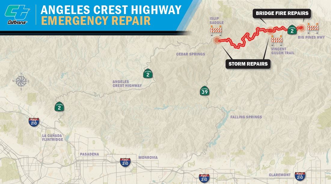
The planned re-opening of the Newcomb’s Ranch diner has been delayed despite being sold. Progress in the most rugged of Southern California’s mountain ranges has never come easy. One bright spot is the reconstruction of the long-dilapidated Clear Creek Information Station by the Forest Service at the junction of Angeles Crest Highway and Angeles Forest Highway. A request for comment to the public information officer for the Forest Service wasn’t immediately returned, but the project appears close to completion with four bright LED lights now shining on the building. Meanwhile, the 66-mile route of Angeles Crest from La Cañada Flintridge to Wrightwood remains closed from Islip Saddle to Big Pines Highway despite some prior speculation that it would open. An information officer for Caltrans District 7 stated about the closed section that it “closes for the duration of every winter after we get the first significant snowfall due to hazardous road conditions.” Crews are at work on three projects within this zone. A previously closed section from Red Box to Upper Big Tujunga Canyon Road re-opened after repairs by Caltrans on July 5, 2024.
“At postmile 65.3 the contractor is backfilling and compacting soil at the top of the slope,” plus “After that they will construct a retaining wall.” Furthermore, “At postmile 66.3 the contractor is continuing to construct another retaining wall.” These two projects relate still to winter storm damage from 2022-2023 that forced the Highway to be closed to Vincent Gap, where trails set off to the High Desert, Mount Baden Powell, the East Fork of the San Gabriel River, and toward the Wrightwood area. Due to the Bridge Fire last August, Caltrans continues to supervise a contractor in removing “a substantial amount of burned trees and continues with the removal.” The spokesman noted, “They continue to repair damaged drainage systems and are installing erosion control on the burned slopes” and that “next the contractor will begin replacing guardrail damaged by the fire.” The cost of these repairs wasn’t immediately available, and work is likely to take some time, as typically rainfall and snowfall if we do get it dislodges additional material.
Caltrans projects that the Angeles Crest Highway is unlikely to fully open until the summer of 2025, which frankly, given the current rate of repair, sounds optimistic. It also would come ahead of the planned reopening of Mount Baldy and the Bridge Fire closure area in December 2025. Ironically, and to some annoyingly, the vendor Bungee America, who operates the bungee jump at the Bridge to Nowhere along the East Fork, remains open, with their public website showing availability throughout the Winter Season. So even as the public remains unable to access the area due to the fire, provided you’re willing to pay to take the leap, you too can access the closure area. The balance between the Forest Service and businesses able to operate under special permits has also been a sticking point for the legions who access the 10,064-foot summit. Were it to rain and/or snow, especially significantly, keeping people out will get harder.
The fine for violating a U.S. Forest Service closure order is $5,000, but at the same time, the agency within the U.S. Department of Agriculture is famously short on enforcement capacity. Whether it snows is the question on many minds, undoubtedly, not the least the new operator of the Mount Waterman Ski Lifts, which first opened in 1939. Angeles Mountain Partners hasn’t had its plan to create an exclusive 100-member first-crack at the powder club, and despite being featured in both the Los Angeles Times and New York Times, it’s not looking good so far this winter. The location lacks snowmaking equipment, and last year it didn’t open until March, and that was after substantial winter storms. A request for comment wasn’t returned, and you really have to wonder what co-founders Joshua Shelton and Scott Towsley thought they were buying. Their plan reportedly would include helicopter access in addition to expanding offerings to include “glamping, mountain coaster, tubing hill, high-end dining and snowmaking capabilities.” The list price for the 390-acre transfer last October was reportedly a handsome $2.275 million.
Much of Mount Waterman remains burned from the 2020 Bobcat Fire, with few signs that the forest will experience full regrowth. In terms of acreage, it’s an LA real estate bargain, but executing such an ambitious plan is highly questionable. It’s also not clear how access would be managed effectively given that in past years, once there’s snow, the masses make for the mountains. Otherwise, the area is actually quite remote, given that it’s along a state highway. Few people actually live in the San Gabriel Mountains in comparison to the neighboring San Bernardino Mountains, and on many occasions, even a full moon, I’ve been the only hiker out enjoying its splendor, as was the case this December on lonely Mount Williamson, a trail that winds up from Islip Saddle at the junction with long-closed Highway 39 from below at Azusa.
Personally, I love the solitude of the mountains, even as many others view it as a racetrack. Even on the trails, you can hear the sound of cars speeding along. Wildlife in the area can be quite shy and also sadly mowed down by the vehicle traffic. Many of the memorials in the High Country of the mountains have been removed, but not by Caltrans, which, although it has a policy in place regarding their installation, has been reticent to remove the crosses that line the highway. The mountain roads can be exceptionally dangerous, most especially head-on collisions from vehicles. Those who crash usually do so not so much from losing control of their vehicles per say as they do from excessive speed. In response to a California Public Records Act request, the Los Angeles Sheriff’s Department refused to disclose accident reports, stating that “Traffic accident records are only issued to involved parties and their authorized representatives.” The Angeles Crest Highway is also patrolled by the California Highway Patrol, which recently, to the chagrin of some drivers, enforced headlight-on requirements even in the daytime between La Cañada and the Clear Creek junction with Angeles Forest Highway.
Were such data to be released, it would certainly help to substantiate the dangerousness of the mountain roads and perhaps help to initiate further safety improvements. The discarded New Year’s hat on Mount Wilson Red Box Road was followed by a discarded 12-pack of Pacifico beer. Angeles Crest was strangely quiet on New Year’s Eve coming back from the desert after the California State Parks Ranger had chased me out promptly at 5:00 pm from Saddleback Butte State Park, which is within the boundaries of Lancaster. The Angeles Forest Highway, which for many is a commuter route, was on December 27, 2024, the site of a “fiery sports car crash” that seriously injured 3 people, including the driver of a Maserati who collided with a Toyota van. According to the KTLA report by journalist Travis Schlepp, “Authorities are investigating the possibility that the Maserati and the Porsche were street racing in the moments leading up to the violent crash.” The collision occurred in daylight at 11:00 am in the morning.
Never before in the history of humanity have we had so much technology at our hands, and yet despite it, we’ve done little to improve the safety of these mountain roads. Whether technology alone, much less regular enforcement, can do much to change what’s essentially a behavioral issue is a question not yet on the agenda. Assuredly, something could be done. The contrast between the LA Basin and the mountains is essentially people, but it’s also machines. One day at the junction between Angeles Crest Highway and Big Tujunga Canyon Road, the morning saw two traffic collisions alone, according to the nearby fire lookouts on Vetter Mountain. Is it time for traffic signals and license plate cameras in the mountains? Equally problematic is illegal dumping. Recently, from my Adopted Section of the Angeles Crest through the Caltrans Adopt-A-Highway program, I’ve pulled out items such as motor oil and discarded bottles of trash, including rubbing alcohol from a camping trip. Changing behaviors is challenging, but clearly the most defining factor is community; it takes networks to create effective enforcement.
Satellite communication devices are more available than ever, and increasingly, cellphones are also gaining such ability. Ideally, more reporting would be the solution; people who commit such acts as dangerous driving or dumping do it because they believe there won’t be repercussions. The mountains of Southern California are places we all love, but we lack effective reporting programs. LASD, for example, doesn’t even have radios that consistently work well in the mountains. Getting to where there’s mountain community versus runaway vigilantism is the challenge, and as of yet, there’s been little discussion outside of social media on how to create a more comprehensive strategic approach to managing these spaces. For many, the wildness is the appeal; it’s a place outside boundaries. Caltrans no longer even has funding for stipends to support clean-up. Some have suggested even the conversion of these routes into toll roads.
A severe Santa Ana windstorm is forecast for next week from January 7 to 9, with the National Weather Service expected to issue red flag warnings. Shifting our mindset from disaster response to disaster prevention is critical. Last summer’s Bridge Fire, which scorched 56,030 acres, was preventable. The East Fork Road and Glendora Mountain Road both remain closed because of it, and numerous homes were lost in both Mount Baldy and Wrightwood to the blaze. Implementing strategic closures in the era of climate change has to be something that we plan on doing more regularly. The Forest Service and Caltrans are under immense pressure to promote recreation, but freedom at all costs, even in the name of protecting commuter routes, is a strategic management mistake. No one wants to see Mount Waterman fully abandoned, but the San Gabriels simply aren’t the place for mass tourism development. According to Los Angeles journalist Lila Seidman, the new owners "pulled down a description of Waterman100 from a web page for the club” to make language changes. They should invite public input.
Journalism is a sector in decline, but it’s critical to creating community, and conversation is how we connect with each other, even more than flashing our blinkers after a car stops to use a turnout. People most certainly need more outdoor recreation options, and we have to continue to diversify the range of mountain users to encompass all of society. Welcoming the community properly should be our goal, as well as keeping it safe for all to enjoy. The outlaw world of the San Gabriels is real down to the burnouts. Agencies such as the Forest Service and Caltrans have to do more to attract volunteerism, and user groups have to self-police. People will often tell you that the designation and subsequent expansion of the San Gabriel Mountains National Monument over much of the Angeles National Forest came with no money, but at least as of October 15, 2024, it now stands at $3.5 million more in addition to the $10.5 million allocated and raised from donors in 2014, according to a press release from Governor Gavin Newsom. More is needed where that came from. Until then, I’ll keep filling up my gas tank to clean up the Angeles Crest Highway with the pride of knowing it’s a needed job well done for everyone.
Government can’t be everywhere, nor should people go to all places. That in the 21st century, with all its technology, we aren’t more ahead of the curve in the backyard of one of the most populated areas in America is highly suspect. Getting the planning going will lead to execution, but until then you have to wonder about our foresight. What’s lacking here in our community? There are dozens, if not hundreds, of people deeply invested in the San Gabriel Mountains community, but it lacks any form of centrality. The mountains will always, to an extent, be about rugged individualism. Groups such as the San Gabriel Mountains Trailbuilders, which has been doing heavy work in reopening the Chantry Flats area, or the Takataka Club, which cleans from La Cañada to Red Box, just might be the most essential element of increasing our successes.
Recently, mountain biker Ray Juncal hosted his annual chili community cookout at Henninger Flats along with Mount Wilson Toll Road on New Year’s Day with two dozen attendees. Altadena Wild and the Chaney Trail Corridor Project continue to work to conserve the Nuccio Nursery at the base of Chaney Trail to the Millard Campground. Together, our ability to succeed in our goals is boundless, but always separately, we’ll get what we deserve. Dangerous conditions and environmental degradation isn’t inevitable, nor does it have to define life in the San Gabriels. The convoy worked its way up the Angeles Crest Highway at night, 10 cars in line, one with its headlights off, and one just over the line. I swerved slightly and went back down the mountains. Let’s hope that 2025 continues to see progress now that the annual celebrations have subsided, and maybe people will keep the party hats on heads and the beer bottles reduced for a change.
Link: With negligible rain in 8 months, Southern California swings toward drought
Link: Mount Wilson Observatory
Link: Saddleback Butte State Park
Link: The feds closed Mt. Baldy to hiking until December 2025. Rebellion is brewing
Link: Clear Creek Information Station
Link: D7-State-Route-2-Emergency-Highway-Repairs
Link: Bungee America
Link: Bridge Fire Area Closure
Link: Partners pitch ‘exclusive’ access to Mt. Waterman ski resort. The Forest Service has concerns
Link: One Ski Resort’s Long-Shot Bet to Survive Low Snowfall and Devastating Wildfires
Link: EXEC: SoCal’s Mt. Waterman Ski Area Sold to Investor Group
Link: Mount Waterman 100
Link: 3 seriously injured in fiery sports car crash in Angeles Forest
Link: San Gabriel Mountains National Monument project gets boost to improve access and water quality
Link: Will changes at San Gabriel Mountains National Monument serve LA’s communities of color?
Link: San Gabriel Mountains Trailbuilders
Link: Takataka Club
Link: Altadena Wild
Link: Chaney Trail Corridor Project
Please support my work with your subscription, or for direct support, use Venmo, CashApp, PayPal, or Zelle using zachary.b.ellison@gmail.com
Zachary Ellison is an Independent Journalist and Whistleblower in the Los Angeles area. Zach was most recently employed by the University of Southern California, Office of the Provost, from October 2015 to August 2022 as an Executive Secretary and Administrative Assistant, supporting the Vice Provost for Academic Operations and the Vice Provost and Senior Advisor to the Provost, among others. Zach holds a Master’s in Public Administration and a Graduate Certificate in Sustainable Policy and Planning from the USC Sol Price School of Public Policy. While a student at USC, he worked for the USC Good Neighbors Campaign, including on their university-wide newsletter. Zach completed his B.A. in History at Reed College in Portland, Oregon, and was a writer, editor, and photographer for the Pasadena High School Chronicle. He was Barack Obama’s one-millionth online campaign contributor in 2008. Zach is a former AmeriCorps intern for Hawaii State Parks and worked for the City of Manhattan Beach Parks and Recreation. He is a trained civil process server and enjoys weekends in the outdoors. Zach is a member of the Los Angeles Press Club.

This is beautiful and well written important information. I love it. Keep up the great work.